


TREAD Map Built an AI-Powered Platform for Smarter Trail Management
Company Overview
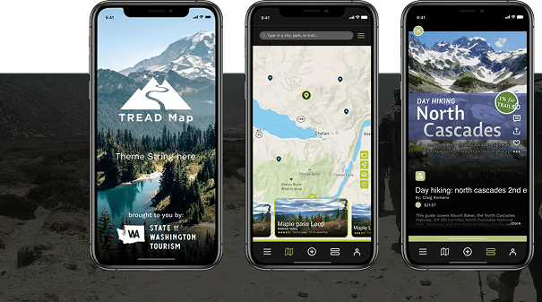
TREAD Map is a SaaS-based social-mapping platform designed to improve communication, safety, and engagement across outdoor trail ecosystems. The application connects land managers, trail users, and local businesses through a unified geo-spatial platform that delivers real-time updates, navigation tools, and location-based insights.
The vision behind TREAD Map was to create a digital information hub that enables government agencies and trail managers to communicate critical updates such as weather alerts, hazards, and emergency notifications to outdoor visitors instantly.
By leveraging geo-spatial AI, machine learning, and real-time data aggregation, TREAD Map enhances trail navigation, improves safety for recreational users and enables local businesses to engage with outdoor communities in meaningful ways.
Project Requirements
Managing outdoor recreational spaces across large geographic areas presents significant operational and communication challenges. Government agencies and tourism authorities required a centralized platform that could provide real-time information, collect user feedback, and improve trail management.
TREAD Map needed a technology partner capable of:
- Building a geo-spatial social-mapping application for multiple user groups
- Enabling real-time communication between land managers and trail users
- Aggregating multiple data sources such as weather alerts, hazard notifications, and traffic updates
- Providing predictive insights to manage trail congestion and usage
- Creating a platform that allows local businesses to connect with trail users and promote services
- Delivering a scalable SaaS application with advanced mapping and analytics capabilities
When Mobcoder AI partnered on the TREAD Map project, the goal was to combine AI-driven mapping, machine learning and real-time data analytics to create a smarter platform for outdoor recreation management.
Our Solutions
Geo-Spatial AI Mapping Platform
We developed a geo-spatial AI-powered mapping system that collects and organizes location-based information from multiple sources, allowing trail users to access accurate navigation data and relevant updates while exploring outdoor areas.
Real-Time Information Aggregation
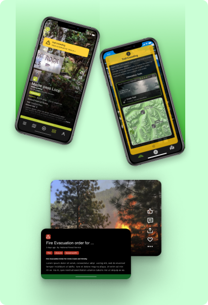
The platform integrates data from expert sources including land manager briefings, weather alerts, traffic updates, hazard announcements, and user trip reports. AI models compile and transform this information into real-time narratives that help users stay informed during their journeys.
Predictive Trail Usage Analytics
Using machine learning and predictive analytics, the system analyzes trail usage patterns and visitor behavior. This enables land managers to distribute visitor traffic more effectively and prevent overcrowding in sensitive areas.
Community Engagement and Business Integration
TREAD Map also allows trail users to create user-generated content such as trip reports and trail updates. At the same time, nearby businesses can promote services and offerings, creating a dynamic ecosystem that benefits both visitors and local communities.
Intelligent Communication Tools
The platform enables government agencies and land managers to broadcast critical safety information instantly, ensuring that outdoor users receive timely alerts about hazards, fires, trail closures, or weather conditions.
AI Tech at a Glance

Geo Spatial AI

Machine Learning

Data Analytics

Al-Powered Mapping

Real-Time Data Aggregation

Predictive Analytics

Key Results Areas
With Mobcoder’s AI-driven development and geo-spatial intelligence capabilities, TREAD Map achieved:
A unified platform connecting land managers, trail users and local businesses
01
Real-time communication of safety alerts, weather updates and hazard notifications
02
Improved trail management through predictive analytics and usage insights
03
Enhanced outdoor navigation and user engagement with interactive mapping
04
A scalable SaaS platform supporting tourism and recreational ecosystems
05
See other case studies

What Our Clients Say
From startups to enterprises, our clients trust us for more than just delivery — they rely on our commitment, clarity, and continuous support. See how we make a difference, one success story at a time.

Ousmane Ouane
VP Product & Business, Sportstech Brands Holding GmbH
Mobcoder's support resulted in the successful release of the apps for fitness devices and the onboarding of thousands of new customers. The professional team worked hard to deliver high-quality work according to schedule. They were highly committed, easy to work with, and efficient throughout.

Todd Williams
CEO, Booking System Software
Direct yet flexible, Mobcoder serves as a valuable development partner for the client. They advise on scoping, work within the client's time zone, and are keen on trial-and-error delivery, making them a perfect fit for the client's workflow.

Mohit Mathur
Vertical Head, Cult Fit
Mobcoder Inc delivered the project on time, and the app didn't have any bugs and had a fast response time. The team was flexible and accommodating to changes even after development. They had a practical approach to the project and communicated through in-person and virtual meetings.